Visual Storytelling Through GIS – Who Do We Serve?
Chesterfield County Public Library
Innovation Synopsis
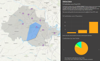
Using GIS analytics, CCPL created a tool to tailor outreach activities and services in areas with relatively low cardholders per population. Using demographics at a parcel level, this community-focused approach allows for micro-targeting, with quarterly updates providing a powerful tool for measuring and optimizing sign-ups and outreach impact.
Challenge/Opportunity
Previous evaluations of who CCPL actively serves in the population were missing the crucial aspect of location, the “where”. Managers had no way of geographically identifying underserved pockets within their communities or determining where to target outreach. Demographic info solely existed at the county-level, too wide a scope for individual branches to tailor services to their unique communities. The ad-hoc nature of past user analyses did not allow for tracking and measuring the impact of outreach efforts.
Key Elements of Innovation
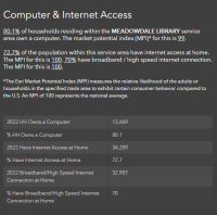
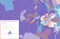
CCPL’s web mapping app visually narrates who lives and uses library services within branch service areas or grouped parcels. Staff can analyze cardholder data alongside demographics and forecasted population growth to identify areas with expired cards or low sign-ups, or areas with barriers to access. Cardholder information like user type, checkouts and OverDrive usage, or demographics like income, race, age, and internet access can also be filtered on. Quarterly updates ensure CCPL meets evolving community needs.
Achieved Outcomes
CCPL’s mapping tool is helping design and improve outreach initiatives, allowing managers to identify vulnerabilities, disparities, and opportunities for action unique to their branch. Even within branch service areas, managers can drill down to the parcel level to target and track card sign-ups in underserved neighborhoods on a quarterly basis. From a broader perspective, the tool assists with system-wide planning and decision-making for equitable resource allocation across all CCPL branches.


